The details of BLM travel management plan for the San Rafael Desert in Utah
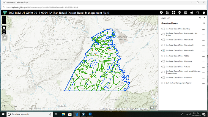
The San Rafael Desert is located on the Colorado Plateau in south-central Utah about 15 miles SW of Green River Utah. A vast, unique, remote high desert environment filled with buttes, badlands, valleys and a rich history of Native American cultures such as: Ute, Fremont, and Paiute.

The Bureau of Land Management (BLM), Price, Utah field office is completing the planning process for updating the Travel Management Plan (TMP) for this area. Once complete, the plan will offer a framework for managing the travel network and transportation systems in this area.
BACKGROUND:
On May 31, 2017 a settlement agreement was reached in the case titled Southern Utah Wilderness Alliance, et al.v U.S Department of the Interior, et al.. This court case required BLM to redo all travel management plans by a certain timeline.
The court found that:
- BLM violated NEPA (National Environmental Policy Act) by not doing enough environmental impact analysis,
- the BLM violated the NHPA (National Historic Preservation Act) by failing to take into account the impact of OHV routes on archeological sites;
- BLM violated FLPMA (Federal Land Policy and Management Act) by not designation enough Areas of Critical Environmental Concern and/or potential Wild and Scenic Rivers
- BLM violated FLPMA by failing to ensure compliance with federal and state air quality standards.
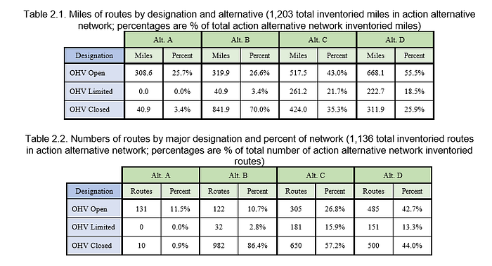
ALTERNATIVES:
Alternative A is keep roads and management as is currently.

Alternative B is pretty much the same as now but adds a few more designated routes.

Alternative C has more additional routes added than Alternative B.

Alternative D has the most additional routes added.
OHV DESGINATION:
Understanding designations is key to understanding the alternatives.
Designated routes are open to motorized-vehicle use by the general public. Undesignated routes include those authorized for specialized use, but not open to motorized‐vehicle use by the general public.
“The plan includes alternatives that designate as open to motorized vehicles which include more than 300 miles of routes that are reclaimed, reclaiming, or do not exist on the ground. Designating these routes is unnecessary and will damage desert soils, vegetation, riparian areas, cultural resources and wildlife habitat.” (from suwa website)
For this project, the action alternative networks (B, C, and D) have a higher number of designated routes than Alternative A (existing management) because the action alternatives brought forward existing undesignated routes (per the 2008 Price RMP).
None of the action alternatives authorize the construction of new routes, and they recognize and designate existing routes based on the best available data.
For this project, the OHV designation for any given route falls into one of the following categories:
• OHV Open — Open year-round to all motorized vehicle travel.
• OHV Limited — Public motorized vehicle use limited to specified vehicle type, width, etc.
- OHV Closed — Route not available for public motorized vehicle use.
CONCERNS:
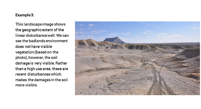
Route proliferation has been and continues to be a concern in the area, contributing to increased conflict among various recreationists, habitat fragmentation, and soil erosion.
Currently, all OHV route use in the TMA is limited to routes that were designated in the 2008 Price RMP and fall under the area designation of “Limited to Designated Roads and Trails.” However, the presence of existing routes that have not gone through a process to formally consider designation creates uncertainty for users on the ground.

The 2008 Price RMP notes, “Growth of OHV use has become a significant issue in the PFO because of the concern related to the possible degradation of resources that can result from high levels of use and proliferation of pioneered routes” (BLM 2008b).
Further, the lack of trail markers and associated maps contributes to public uncertainty on which routes are available for use, as well as general navigability and public safety. (from EA)
Archaeological/Mammal/Fish/Bird/Plant Species:
The Class III Survey identified 231 previously and newly-recorded cultural resource sites.
Endangered, Threatened, Candidate, and BLM Sensitive Mammal Species (Great Plains toad, Kit Fox, Spotted Bat an dmore)
Endangered, Threatened, Candidate, and Conservation Agreement Fish Species (Humpback chub, Colorado Pikeminnow-found within Green River)
Endangered, Threatened, Candidate, and Sensitive Bird Species (Mexican spotted owl habitat, Southwestern Willow Flycatcher) (pages 101–134)


GOALS:
Establish management that provides necessary public services, authentic recreation experience, and opportunity within allowable use levels; minimizes user conflicts; and maintains the healthy ecosystems and settings that provide the basis for recreation opportunity and experience. Provide an environment for and encourage entrepreneurial activities that are supportive of the recreation program goals and objectives
MORE INFORMATION:
Additional information about the San Rafael Desert Travel Management Plan Draft Environmental Assessment can be found on ePlanning at: https://go.usa.gov/xVg2y
Travel Management Plan Map: https://eplanning.blm.gov/epl-front-office/projects/nepa/93510/169298/205893/Utah_Price_TMA_Settlement_Map.pdf
Environmental Assessment: https://eplanning.blm.gov/epl-front-office/projects/nepa/93510/20010207/250013168/San_Rafael_Desert_Draft_Environmental_Assessment_12-13-2019.pdf
Southern Wilderness Alliance information: https://suwa.org/blm-wants-to-open-up-san-rafael-desert-to-twice-as-much-motorized-use/
SUWA Story Map: http://suwa.maps.arcgis.com/apps/Cascade/index.html?appid=07926228355c4b8e9fa1cdbb7ca59c39
HOW TO COMMENT:
The San Rafael Desert Travel Management Plan Draft Environmental Assessment 30-day formal comment period is underway until 1/13/20.
Please, reference the San Rafael Desert TMP when submitting comments.
Submit comments to the project manager:
BLM Green River District Planning and Environmental Coordinator, Ann Glubczynski
Bureau of Land Management
170 South 500 East
Vernal, Utah 84078
Email: BLM_UT_PR_Comments@blm.gov
Fax (435) 781–4410
For more information, call Ann Glubczynski at (435) 781–4474, or the BLM Price Field Office at (435) 636–3600.
Take Action SUWA comment link: https://secure2.convio.net/suwa/site/Advocacy?cmd=display&page=UserAction&id=1256
Before including an address, phone number, email address, or other personally identifiable information in any comments, be aware that the entire comment, including personal identifying information, may be made publicly available at any time. Requests to withhold personal identifying information from public review can be submitted, but the BLM cannot guarantee that it will be able to do so.
FUTURE:
BLM will issue a new TMP within the following time line since the settlement was reached in 2017.
Includes:
Henry Mountains and Fremont Gorge (2.5 years)
Dinosaur (north) 3.5 years
Book Cliffs 5.5 years
Nine Mile Canyon 7 years
San Rafael Swell 4.5 years
Indian Creek 4 years
Labyrinth/Gemini Bridges 6 years
Dolores River 8 years
Trail Canyon 4 years
Paunsaugunt Canyon 6 years
All words are of my own and do not represent SUWA or BLM/DOI.
*Opinions expressed are solely my own and do not express the views or opinions of my employer.